Country Club Apartments. Cameron Park, CA. AUG 2022 Final Report. |
|
|
This report analyzed short term and long term scenarios for the proposed Country Club Apartments Affordable Housing residential development, consistent with the requirements found in El Dorado County Community Development Agency’s Transportation Impact Study Guidelines. The “with and without project” scenario analysis results are summarized in several tables and graphics in the body of this report, and duplicated in this section for convenience. There are a total of ten (10) intersections analyzed in the study area, four of which are signalized intersections, and the remaining six are stop sign controlled.
|
|
The existing Year 2022 conditions in the study area are at LOS D or better conditions, and no improvements are required. No traffic signals are warranted.
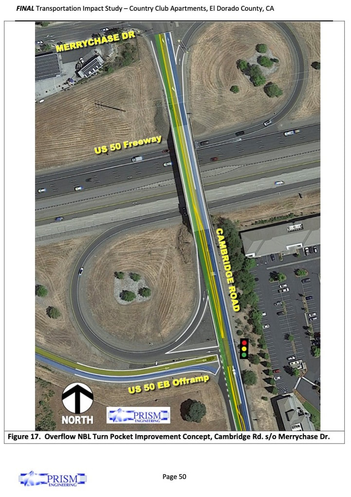
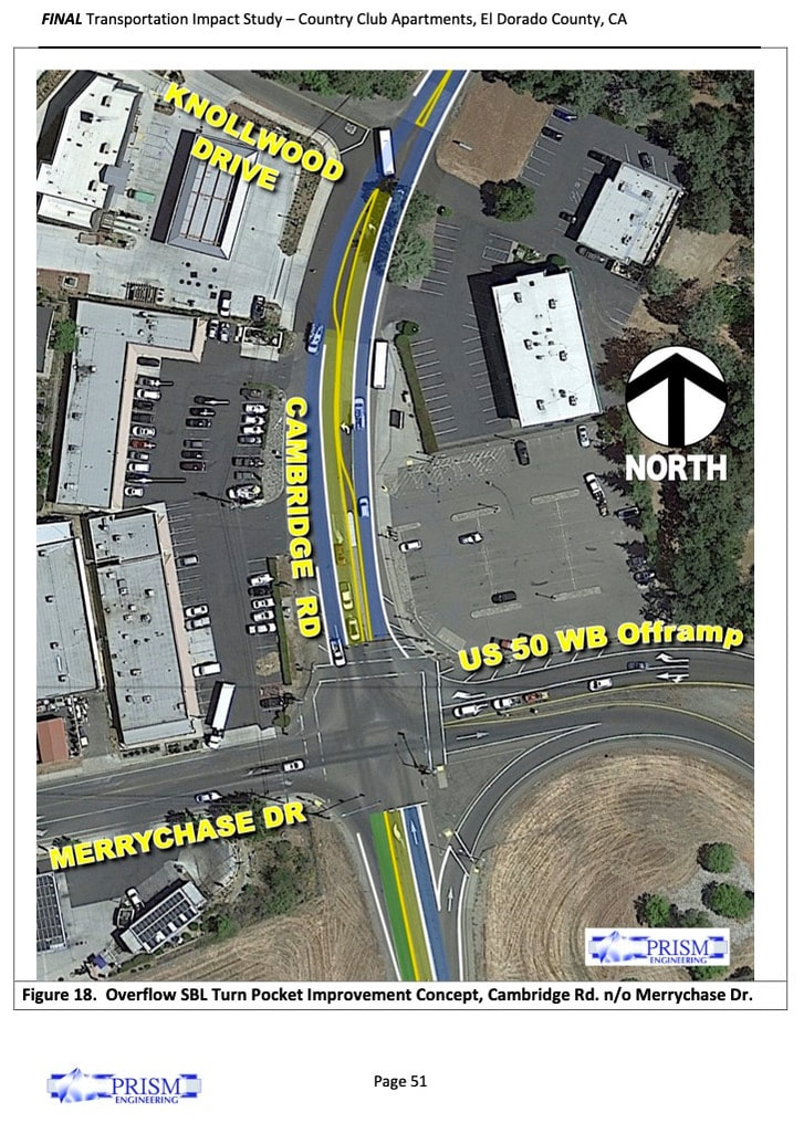
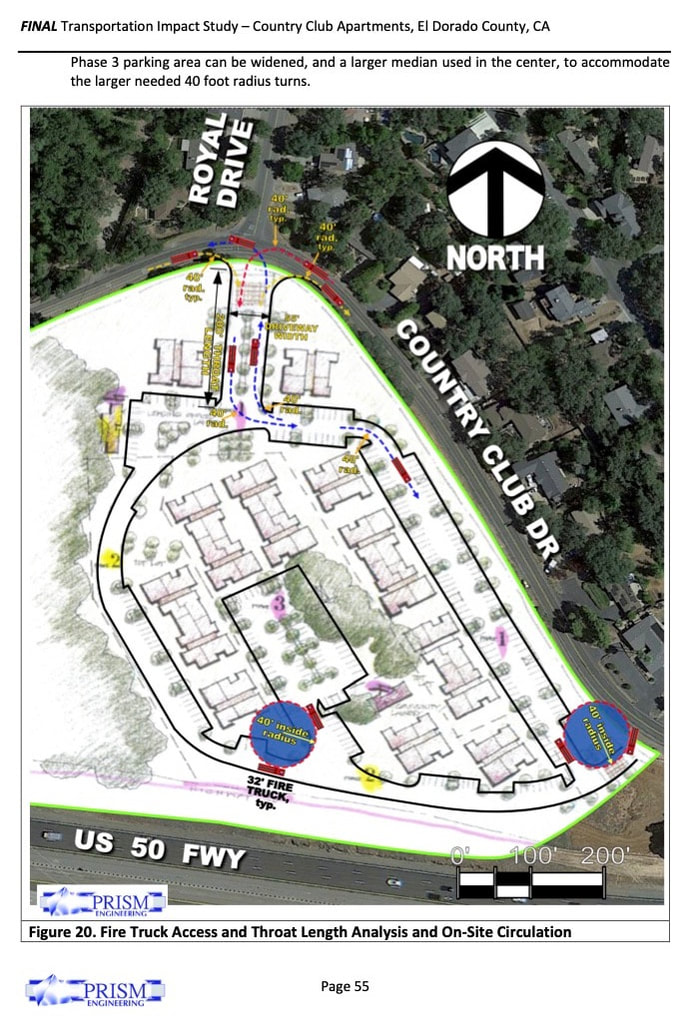
The future Year 2032 conditions in the study area degraded with background traffic growth, and ranges from LOS A conditions at low volume unsignalized intersections, to LOS F conditions at the US 50 EB Offramp and Cambridge Road intersection, as well as at the intersection of Cambridge Road and Country Club Drive. There are also queue overflow problems projected at signalized intersections on Cambridge Road and on Cameron Park Drive. A new traffic signal installation is recommended for the Year 2032 pm peak hour conditions at the US 50 EB Offramp intersection with Cambridge Road, as well as at the intersection of Cambridge Road and Country Club Drive. OSTR: Truck and Large Vehicle Access, 32 Foot Long Fire Truck PRISM Engineering utilized the site plan concept, and aerial photography to scale the project into and adjacent to the surrounding street system as shown in Figure 20, Fire Truck Access and Throat Length Analysis and On-Site Circulation. This figure utilized the standard of a 32 foot long fire truck, and superimposed that design vehicle onto the site plan, using a 40 foot inside turning radius as the pathway to see if the fire truck could easily navigate the site. In general, such a fire truck can navigate throughout the site with ease, and without any need for a three point turn. However, based on our findings there are a couple of locations in the site plan that need adjustment so make it possible for a 40 foot inside turning radius pathway. These are shown on Figure 20 with dashed lines and an arrow, with a firetruck associated with each dashed line/path shown. Different colors were used to differential between overlapping scenarios of inbound and outbound traffic pathways. The following areas need specific adjustments to internal roadway alignment and landscaping: • The northeast corner of the site needs to have the exit throat curve radius pulled back significantly to allow for a 40 foot turn radius. A truck pathway is shown for this with a yellow dashed line. • The southeast corner / emergency access point has some tight turn radii, but the primary trouble spot is the parking area that is too close to the lower onsite intersection and should be moved further west so a larger radius corner can be installed there. • The third location where a potential problem spot exists is the internal area planned for Phase 3. It is not possible to have 40 foot radius curves throughout the parking area, and should be redesigned so that the inside curves can allow a fire truck to loop around to make the exit. This |
photo/video/drone footage and aerials © 2022 PRISM Engineering
EMERGENCY RESPONSE! Fire Engine Response Planning Study. Feb 2019, Fairfield, CA
|
|
PRISM Engineering conducted a comprehensive emergency fire engine response time study to determine if adequate emergency response times are in place according to established standards (NFPA 1710). Out of nine nearby fire stations, 3 were within the standards, and only one needed to be. A complete report with tables and graphics was prepared to document all findings, and detailed times on all travel paths. Google Maps App was also researched to make comparisons of actual drive times in the field, and to verify. The purpose of the study was to find out through engineering methods (research, measurements, analysis, and summary) what fire engine response times from various fire stations proximate to the project site would be, by physically measuring and video recording actual driving times from each station to the site, adjusting times for red lights along the way, considering the effects of traffic congestion, and taking into consideration what happens when a fire engine deploys traffic signal pre-emption to bypass a red light at an intersection, etc. In addition, “big data” from Google Maps was also used, a publicly available data set that documents the ranges of time that drivers experienced along a certain path while using the Google Maps App. A detailed info-graphic and summary matrix and report were prepared to show optimum pathways and times from nine different nearby fire stations to the project site, during the “worst case” pm peak hour time period.
|
photo/video © 2019 PRISM Engineering
ROUNDABOUT in 2018/2022-- In El Dorado County: Dorado Oaks Residential Development in Diamond Springs UPDATE: Traffic Impact Study and Operations Analysis and |
|
This study includes a comprehensive Traffic Impact Study, a Traffic Operations Analysis and Micro-simulation model(s) for the Missouri Flat Road corridor from Plaza Drive to SR 49 Pleasant Valley Road (2 miles). Multiple scenarios were analyzed for Year 2017, 2025, and 2035 conditions with and without the project. Detailed analyses were performed using calibrated micro-simulation SimTraffic models, and mitigation measures explored along with the future Diamond Springs Parkway bypass in the Travel Demand Model network.

|

FIG 1: Existing Condition lacking capacity, intersections too close and narrow to mitigate. |

FIG 2: Proposed Roundabout solves capacity, speed, geometry, and LOS for Project Expansion |
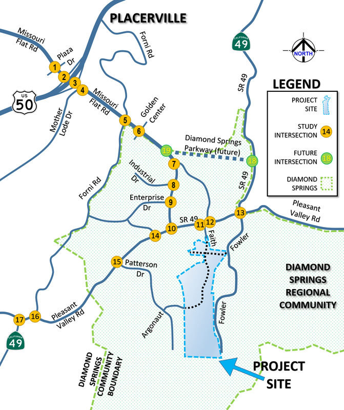
Project is 400 Residential Dwelling Units
Coming up with solutions for this study was particularly challenging:
1) There is a new bypass that will change traffic patterns in the future.
2) There is a narrow historical road which serves as State Highway 49 which can't be expanded or signalized easily. So a roundabout solution was sought to preserve the historical buildings, prevent widening, and keep speeds reasonably slow and safe.
3) Access issues abound where driveways are numerous and sidewalks are not installed.
4) Bike lanes are missing because of narrow roads and right of way issues
5) New development is required to find more connectivity between neighborhoods, and minimize impacts by encouraging walking, biking, and use of transit where possible.
Transportation Planning requires an understanding of traffic characteristics, trip generation, etc.
At PRISM Engineering, we build a solid baseline of existing conditions to establish traffic patterns, then build on that and analyze the future...
photo/video © 2019 PRISM Engineering
Roundabouts serve multiple purposes: Slow Traffic Down, Decrease Severe Accidents, Increased Capacity, Mitigate Skewed and/or 5 legged Intersections, Offset Intersections, etc.
At PRISM Engineering, we look for proper application of Roundabouts, as well as Signalized intersections, depending on the situation and needs...
Modern Roundabouts Require Cooperation to FunctionA huge difference in the way roundabout operate in the USA versus in China is that in the USA there is a cooperation between drivers based on a YIELD ON ENTRY rule, where drivers entering a roundabout actually wait for a gap in traffic, and not the other way around. The drivers inside the circle already do NOT stop for other drivers coming in, they don't slow down, they don't give way... the expectation is that drivers inside the roundabout already need to be able to get out easily, or else the whole roundabout is gridlocked. Once a driver stops inside the roundabout, it will gridlock for all movements. The MAIN LANE in the roundabout that just always be free-flowing, is the circle lane(s). In China, drivers entering the roundabouts sail in and even cut off drivers already inside the circle, and they also exit the roundabout from the innermost lane making a sweeping cut-off maneuver to other drivers in the roundabout, causing them to slow or stop to avoid an accident. This is a capacity defeating behavior. CLICK ON EXPANDABLE ITEM BELOW TO SEE DOCUMENTARY VIDEO ON CHINA ROUNDABOUTS. |
Typical small Roundabout in Fresno, CA, Feb 2018Yield on entry is well established. 10 years ago this was not the case as many cars did not yield on entry photo/video © 2019 PRISM Engineering |
A SAMPLE OF A HUGE ROUNDABOUT IN CHINA, VERY DIFFERENT FROM USA.. (CLICK TO SEE)
Video Documentary: Navigating a large 500' diam. Roundabout in China, on an electric Scooter 骑电动车的时候 (circa Aug 2015, Fuxin 在阜新市, Liaoning 辽宁省Province, China)
Zhong hua lu 中华路 roundabout. diameter = 500’ . 5 vehicle lanes, 1 bike lane. X-WALKS on 4 of 5 approaches
PRISM Engineering creates
|
|
Using industry standard travel demand software our traffic models have high levels of detail to facilitate the more accurate assignment of traffic from zone to zone, and a better trip distribution between trip purposes and modes of traffic.
|
|
Big Picture Transportation Planning
|
PRISM Engineering routinely collects big picture data to be used in transportation planning, to enable better results from having a higher understanding of what the real transportation issues are, as a system of intersections and roads. PRISM has invested in aerial videography services and capability to study and analyze real world traffic conditions. This data enables an understanding of the bigger picture which can not be obtained from analyzing traffic count data alone. Our Traffic Impact Studies and other Transportation Planning Studies are better informed relative to existing conditions and constraints.
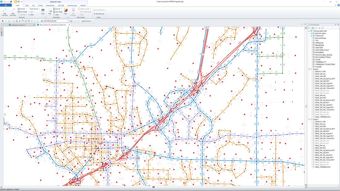
1. TRAVEL DEMAND MODELINGPRISM Engineering is experienced in the use of numerous travel demand forecasting and land use planning software packages, and can run the model in any city or county as needed to aid in transportation planning and traffic impact studies, specific plans, etc. We also work seamlessly with output from traffic demand models to develop future traffic volumes for traffic impact and planning studies.
|
|
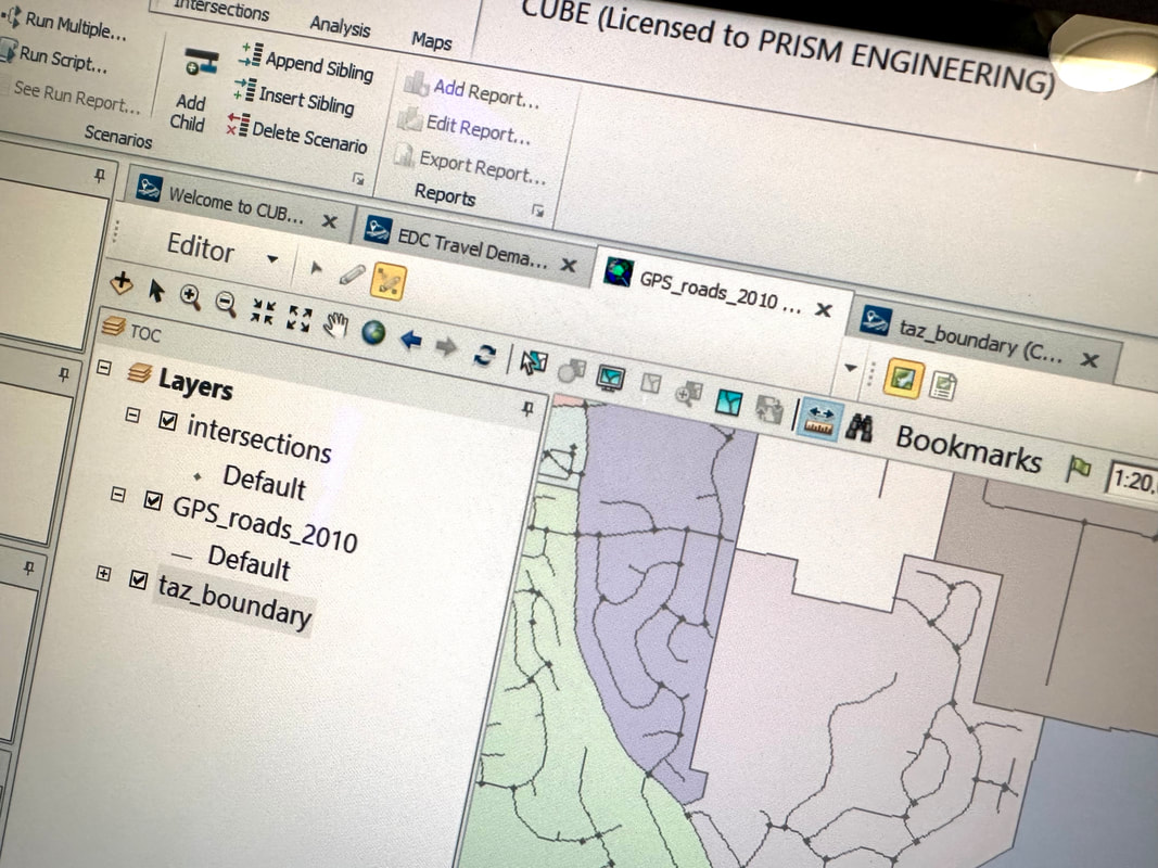
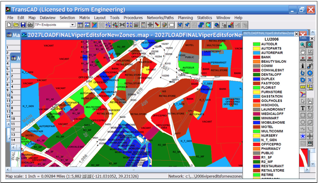
Grant Johnson is working with the latest CUBE 6.5 software in Vacaville, CA, and El Dorado County. He has created 600+ TAZ TransCAD traffic forecast models for Nevada County, the City of Los Banos, and numerous cities and counties (30+) since the inception of traffic demand modeling on microcomputers in 1985. He worked then with MINUTP, the very first version of traffic models on a PC before it morphed to Cube by Citilabs. His experience with the procedures and methods of traffic forecasting are extensive.
photo/video © 2019 PRISM Engineering
photo/video © 2019 PRISM Engineering
|
PRISM Engineering uses Traffic Forecast Models
|


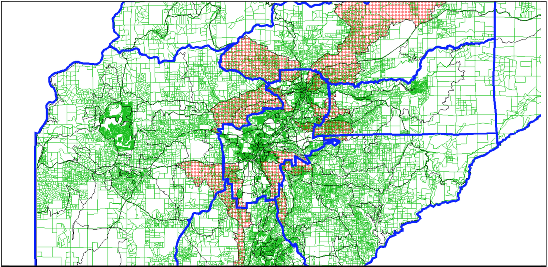
This study was city-wide and examined a freeway bypass to the city
|
|

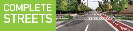
2. MULTIMODAL CORRIDOR STUDIES
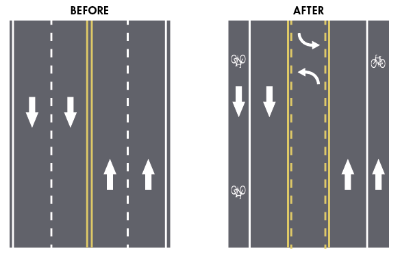

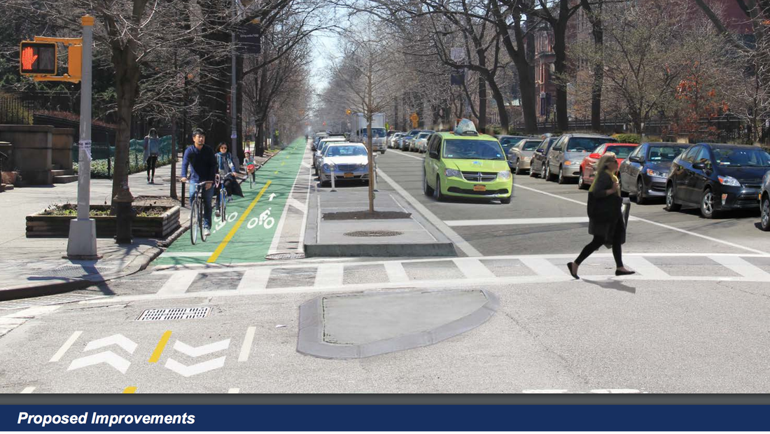
PRISM's approach to helping solve today and tomorrow's future traffic problems is MultiModal. We think in terms of not just cars, but how the bikes and pedestrians fit into the system as a whole. Complete Streets. Grant Johnson has spent 2.5 years in mainland China observing and participating in the largest multi-modal systems in the world. He also supervised construction of the newest bullet trains near Beijing. As a way of life, he walked to work, rode buses and bullet trains and monorail transit with his family on a daily basis. They never owned a car or drove. They rode bikes, electric scooters, and experienced a level of fitness and satisfaction that is mostly unparalleled in the USA. His vision of traffic includes making room for bikes and peds on the streets, and not just making traffic operations for vehicles better. Indeed, it is a holistic approach that looks at the big picture. He believes we can learn from China on this matter, and make room for all modes of traffic, because they are already doing it successfully for most all people there.
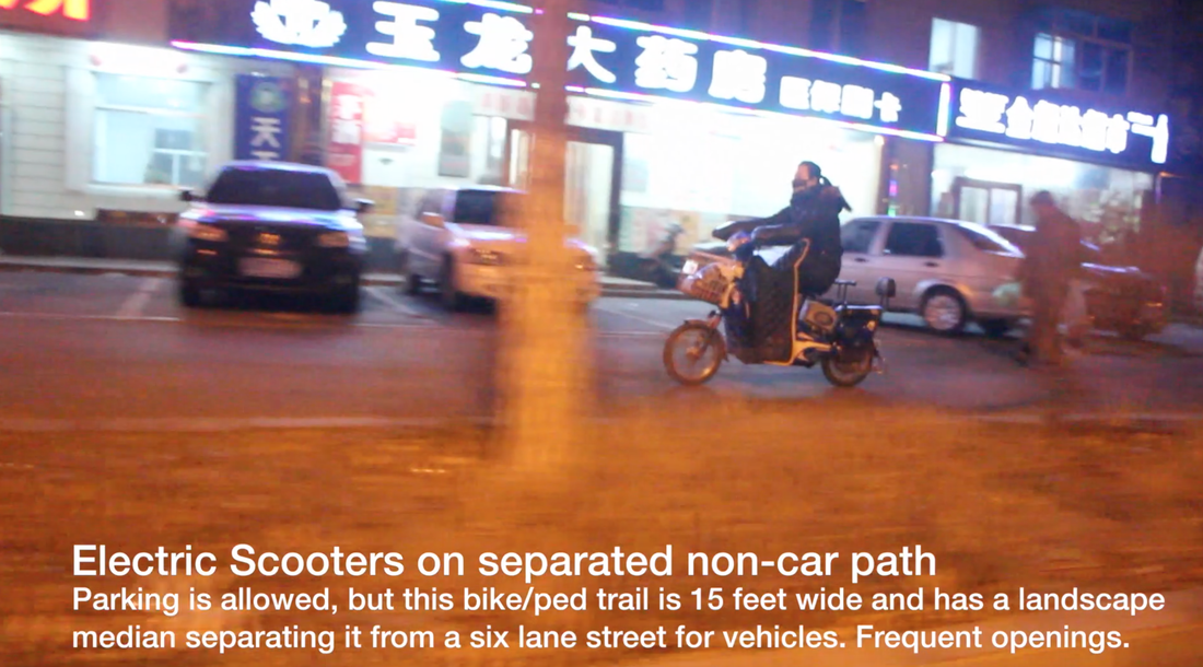
It is ideal to separate the different modes of traffic, to improve safety and desirability to use non-vehicular modes of travel.
|
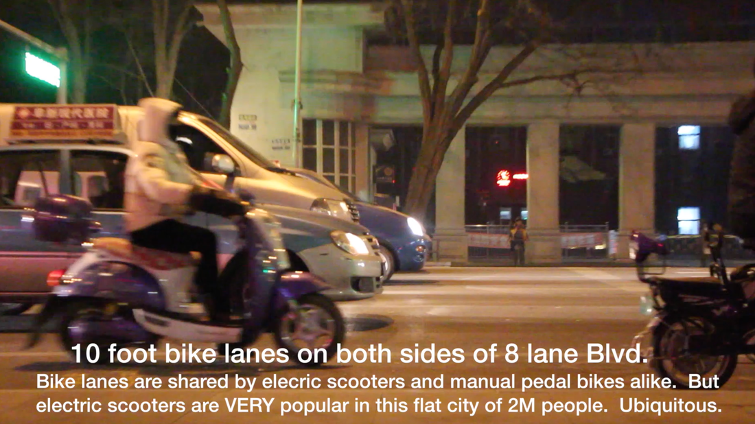
In the USA, Complete Streets is still evolving and seeking a standard, and has been improving. The challenge is finding the funding and community will to provide adequate bike and ped facilities in an appropriate ratio to vehicle facilities. Safety is of primary concern, especially where bike and ped systems are not ubiquitous and where bikes and vehicles share the same road / lanes. Not ideal.
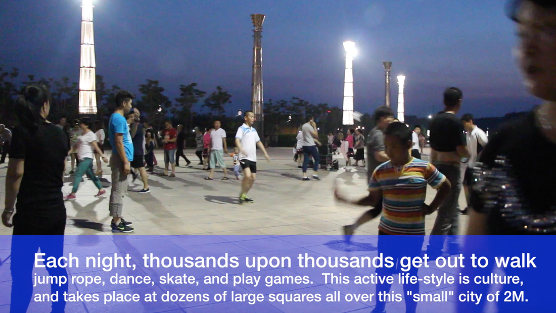
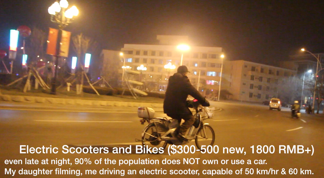
Watch this video of a multi-modal environment in a small city in China of 2M people. Cars have been separated from bikes and peds in this system of lane striping, but not all drivers obey the striping and there is no police enforcement in China to encourage compliance to lane striping or bike and ped facilities. Drivers of cars can still park on many sidewalks, or taxis and buses can completely block bike lanes. Drivers of cars and trucks still do use intimidation rather than caution when dealing with sharing the road with cyclists or pedestrians. Watch below... ⬇︎⬇︎
|
CHINA has implemented numerous Multi-Modal Transportation FacilitiesIt is very similar to Complete Streets... and it works better than if there were no facilities for peds or bikes. However, China has a vehicle related fatality rate 10 times that of the USA per 100k vehicles on the road. This indicates that the more pedestrians and bikes there are on the road, that the number of fatalities will also rise because pedestrians and cyclists are more vulnerable to severe injury from a high speed vehicle. Check out the video of a multi-modal culture in mainland China.
There is no "once size fits all" solution to multi-modal transportation solutions. Each locale is different. Different terrain, different climate, different culture, etc. The main difference between USA and China is that China has an emphasis on personal responsibility for safety (less rules) and the USA approach tries actively to enforce safety through law enforcement. Certainly this has to do with the different housing densities. Both countries have similar accident rates and severity despite these differences. Personal responsibility means that drivers and ped and cyclists do not take it for granted that they are safe. The accident statistics for each country say that we are still not safe. Complete Streets can encourage a more active lifestyle, but we are still mixing vehicles that move fast with bikes and peds that do not go fast. The result is a much higher level of danger to those who are not in the vehicle. |
photo/video © 2019 PRISM Engineering
|
|
A Multi-Modal CULTURE in mainland CHINA where people walk, ride bikes, skate, jump rope, dance, play games/sports, and hang out with a cross section from every age demographic all in the same places. This culture encourages the development of multi-modal facilities including wide sidewalks, wide bike lanes, separated bike and ped paths, transit, and electric scooters.
|
3. TRAFFIC IMPACT STUDIES and ANALYSIS
|
Traffic Impact Studies are the traffic accountability tool needed to compare future conditions with existing conditions of traffic. When PRISM Engineering conducts a traffic impact study or analysis, we first get a solid handle on the existing conditions and validate that information and analysis with a real world check. This builds credibility with the reviewing public. Then future volumes are created from these existing volumes using growth rates determined from the local traffic demand model.
| ||
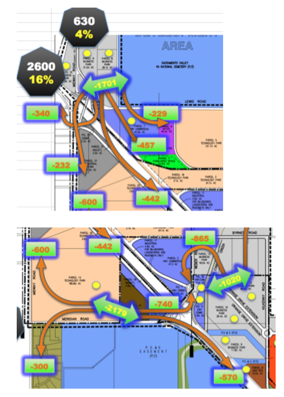
INFOGRAPHICS to better COMMUNICATE

INFOGRAPHIC created by Grant Johnson, TE, for use in Traffic Impact Study
|
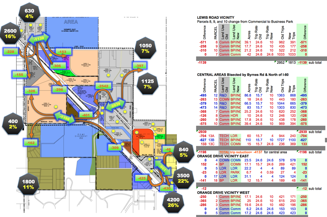
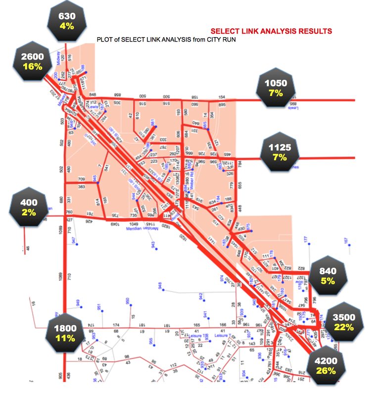
PRISM Engineering has always created detailed INFOGRAPHICS as a part of Traffic Impact Analysis and Corridor Study. These graphics tell a story and illustrate usually in ONE figure, many things. Without confusing the reader with overload of information, our graphics can be studied because they have multiple layers of information. For example, a figure that shows the proposed street and intersection improvements, but also overlays the project traffic and even shows the trip distribution of the alternative that works best. This way the reader can see the "big picture" rather than shuffle back and forth to independent figures and try to composite the information in their minds. We feel this higher level of communicating complex data helps to build bridges of understanding, to paint a more complete picture.
|
In this graphic above we see the project site plan, the project's trip generation for Alternative 3, the project trip distribution at all surrounding intersections, the directional split of project traffic inbound and outbound delineated by dashed lines which are color coded to differentiate, we see adjacent proposed projects such as the post office and their traffic, we also see the recommended STREET IMPROVEMENTS in place along with proposed striping and raised medians and traffic control to get a very good idea of what is taking place in this future condition. A reviewer of this report can quickly get an idea of what is analyzed and what is proposed, all in one graphic. Similar graphics are prepared for other alternatives in the Traffic Impact Analysis Report.

4. TRANSIT STUDIES and DESIGN

As a part of Grant Johnson's work in Chongqing China, city of 38 Million people, he was tasked with designing multi-modal transit and bike plans for a NEW TOWN in the YueLai northern area of Chongqing China. This work effort required working with preliminary civil engineering plans and first determining the road Right of Way street width needs, and then developing a lane and striping plan for dozens of miles of roadways. Using AutoCAD, he developed another layer of proposed bus stop locations using industry standard spacing for frequency of stops, and developed a travel path for the several bus lines that would serve the 4 square mile area of streets in the new town adjacent to a major freeway.
|
|
On another layer using topography as a guide, Mr. Johnson developed a bike lane and trail plan for the new town with Class II and Class I facilities only (no shared lanes), because it is important in China to not have bikes share the lane with automobiles. By providing sufficient road ROW widths, it is possible to have separate and safer bike lanes, ped sidewalks and paths, etc. Bus turnouts and on-street parking were also designed into the layers of proposed improvements. COMPLETE STREETS concepts and principles were applied to the design of these streets, to narrow roads when possible, shorten crosswalks for PEDS, and provide separate bike pathways. In addition, China's Transportation Standard Plans were referenced to meet the local requirements.
|
|
|

|